Austin Creek
District Watershed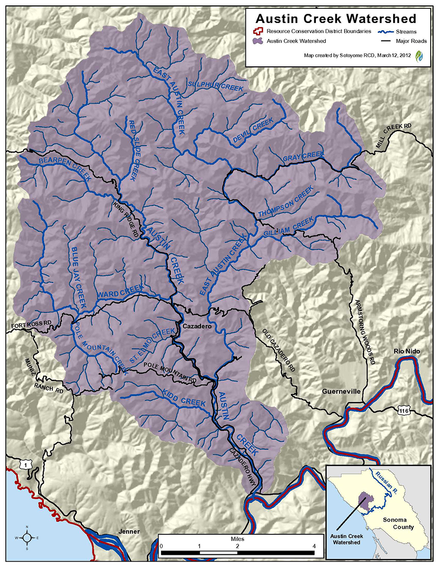
Watershed Overview
The Austin Creek watershed drains approximately 68.7 (110 km) square miles of land, and includes approximately 175 miles (281 km) of blue line stream. The watershed is made up of two major drainage basins. The main drainage basin is Big Austin Creek, and its primary tributary creeks include: Ward, Bearpen, Kidd, and St Elmo Creeks. The main basin covers 37.9 miles (60.9 km). The other major drainage basin is East Austin Creek, which meets Big Austin Creek near the center of the entire Austin Creek watershed. Its primary tributary creeks are Grey, Gilliam, Schoolhouse, Devil, and Sulphur Creeks. The East Austin Creek drainage basin covers 32.0 miles (51.5 km). The Austin Creek watershed is dominated by steep mountains. Elevations range from near sea level at the confluence with the Russian River to about 2320 feet on Mohrardt Ridge, which is the divide between Ward Creek, Bearpen Creek, and the Gualala River watershed. Big Austin Creek is a 16.0-mile-long (25.7 km) southward-flowing stream in the mountains of western Sonoma County, California, and empties into the Russian River about 4 miles (6.0 km) from the Pacific Ocean. The creek originates in an isolated area about 13 miles (21 km) west of Healdsburg, California. It flows south into wooded canyons, where it joins King Ridge Road just above its confluence with Bearpen Creek. It parallels King Ridge Road along the town of Cazadero and continues south through confluences with East Austin Creek and Kidd Creek. It flows under State Route 116 at milepost 4.93 and enters the Russian River about 1 mile (1.6 km) upstream of the town of Duncans Mills. There are no incorporated cities within the boundary, and the watershed is about 90% privately owned with about 10% held by state entities. In addition to private property owners and state-owned property, there are properties held by the Sonoma Land Trust in the Austin Creek watershed.
Land Use
Today major land uses in the Austin Creek watershed include timber harvest, quarrying, gravel mining, recreation, grazing, and rural development. Rural development is concentrated along Big Austin Creek and in the Cazadero area. All residential units are on septic systems and wells and many have private dirt roads. Historic land uses in the watershed included much heavier logging as well as magnetite mining (Russian River Basin Fisheries Restoration Plan, CDFG 2002). In the 1800s, the North Pacific Coast Railroad extended its narrow-gauge line up Austin Creek to transport lumber from Cazadero to the south. The railroad grade was later converted to road, becoming Cazadero Highway. Sonoma Magnesite Company was formed in 1912 to mine magnetite in the Austin Creek watershed. In 1914, an eleven-mile 2-foot-gauge industrial railway was built along the bank of East Austin Creek to connect the mine with “Magnesia” station on the North Pacific Coast Railroad south of Cazadero. Thirty tons of ore were processed daily in an oil-fired rotary kiln and packed into sacks for shipping. The mineral is important for steel-making and manufacture of bricks for high-temperature applications; but cost of transportation made mining impractical and production ended in 1920.
There are a total of 356 miles of roads in the Austin Creek watershed. Overall the ratio of miles of roads to square miles of watershed is high, with a ratio of 5. A ratio of <2 is recommended for a watershed to support anadromous fish (Meehan, 1991). Reasons given for the detrimental effects of roads include the fact that the slopes at which most roads are built tend to inhibit the natural dispersal of water thereby concentrating runoff and creating gullies and landslides. In addition, road networks have created drastic changes in the natural drainage patterns of the watershed through increasing the amount of impervious surfaces and diverting water to follow roads rather than natural patterns. Assessment and prioritization of excess sediment sources in the Austin Creek watershed is also ranked as a high priority in the CDFG’s Coho Salmon Recovery Tasks. At a Level D task, it means sediment reduction projects must be implemented rapidly or early in the coho salmon recovery process because it is critical to establish coho salmon rearing grounds.
Vegetation
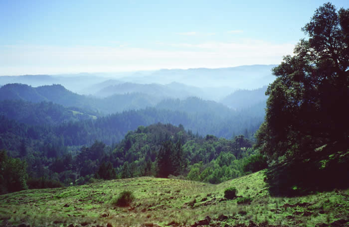
A variety of vegetation types, including coniferous forest, redwood forest, and cypress forest hardwood forest mixed hardwood/coniferous forest, chaparral and grassland cover the Austin Creek watershed. Hardwood and conifer forests are the primary types of vegetation. Hardwood forest is more concentrated around the perimeter of the watershed and redwood, closed cone pine-cypress and Douglas fir represent the largest coverage of vegetation in the Austin Creek watershed. As a result of the abundance of serpentine rock and soil present in the Austin Creek watershed, a diverse serpentine flora exists and, many rare plants in the watershed are serpentine endemic species.
Fish and Wildlife
Several listed species are found within the Austin Creek watershed. Among the endangered species are the Oncorhynchus kisutch, coho salmon, and the Syncaris pacifica, the CA freshwater shrimp. Threatened species that have been documented in the watershed include the Rana draytonii, CA red-legged frog, the Oncorhynchus mykiss, the steelhead trout, and the Strix occidentalis caurina, northern spotted owl. Habitat levels for each of these species vary throughout the Austin Creek watershed. To improve habitat in the watershed, recommendations include increasing riparian canopy, road repairs to reduce sediment delivery into stream, and increase instream habitat with structure installation and wood retention.
Current and Past RCD Programs
Watershed Planning
- RCD completed a Watershed Assessment of Austin Creek: View & Download PDF. This watershed-wide assessment utilized historical documents, several decades of aerial photography, and current geo-spatial information to analyze the watershed and assess current conditions. The final report discusses erosion problems, areas of major vegetation changes, and other issues related to water quality and anadromous fish habitats. The assessment also includes recommendations to improve water quality and aquatic habitats within Austin Creek and its tributaries.
On-the-Ground Projects
- The RCD completed storm-proofing 56 sediment source features on 9.39 miles of hydrologically connected roads for a total of 8,111 yd3 sediment savings. The roads were near Gray Creek, a tributary to Austin Creek. Implementation was made possible by the Department of Water Resources Proposition 84 Integrated Regional Water Management program, The Coastal Conservancy, and the Department of Fish and Wildlife.
- The RCD implemented a Large Woody Material (LWM) project on Thompson Creek, a tributary to Austin Creek. The goals of the project were to provide additional pools, shelter, and increase gravel sorting and storage to improve available spawning habitat. The project added 21 pieces of LWM to the low flow channel, a seven-fold increase relative to pre-project conditions. Funding was provided by the Department of Fish and Wildlife.
- The RCD implemented eight Large Woody Material (LWM) sites with a total of 23 logs on Gilliam Creek, a tributary to Austin Creek. The goal of the project was to increase habitat complexity, cover, pool scour, and high flow refugia for coho salmon. The project was made possible from funding from the Department of Fish and Wildlife.
- The Austin Creek Watershed Restoration Program involves the RCD actively working with private landowners and public lands managers within the Austin Creek watershed to develop and implement projects to enhance riparian and instream habitat, stabilize eroding stream banks, and decrease anthropogenic fine sediment inputs into the stream system. With funding provided by the CA Coastal Conservancy, Sonoma RCD implemented in 2012 the Gilliam Creek Instream Habitat Restoration Project – Phase I. Also to be implemented in 2012 was the Thompson Creek Instream Habitat Restoration Project funded through the CA Department of Fish and Game’s Fisheries Restoration Grant Program. Gilliam Creek and Thompson Creek are major tributaries of East Austin Creek and both projects involve the placing of large wood structures in the creeks in order to enhance conditions for salmonid habitat.
- The RCD is actively working with landowners and public lands within the Austin Creek watershed to develop and implement projects to enhance riparian and instream habitat, and stabilize eroding stream banks. Austin Creek is a focus of the RCD’s Rural Roads Improvement Program. Sonoma RCD began implementing the Austin Creek Sediment Source Reduction Implementation Project in 2013 and it will continue through 2014. This project will enhance, protect, and restore salmonid habitat by controlling and preventing road-related erosion and sediment delivery at 96 sites in the watershed identified as a part of the comprehensive “Austin Creek Watershed Assessment and Inventory project” conducted in 2010-2011. Cost effective erosion control and erosion prevention techniques will eliminate delivery of more than 13,000 yd³ of sediment into the Austin Creek watershed.
Water Resource Management
- The RCD has conducted general water quality monitoring throughout the Austin Creek watershed during the summer months since 2005, and ended in 2012. This program has been funded primarily by the Sonoma County Water Agency, and initially by the State Water Resource Control Board. During the past seven years, temperature data loggers have been placed throughout upper and lower reaches of Big Austin, East Austin, and Kidd Creek. Bacterial monitoring was conducted in 2004-06. In 2004 and 2010, macroinvertebrate sampling was conducted in Upper Big Austin, and in Kidd Creek in 2004. Bulk sampling, to quantify baseline sediment composition, was conducted in 2004-2006 in Upper Big Austin, East Austin, and Kidd Creeks. Streamflow and rainfall gauging records cover a few years. Restoration actions are evaluated and informed by quantitative monitoring, and water quality and quantity monitoring, ideally long term which provide quantitative results, has aided in determining trends that indicate the success of Austin Creek watershed projects and programs that are put in place to improve aquatic habitat throughout the watershed
Links to Partner Programs in the Watershed
For more information about the Austin Creek Watershed, please contact Aaron Fairbrook at 707.569.1448 ext 106 or afairbrook@sonomarcd.org.