Stemple Creek
District Watershed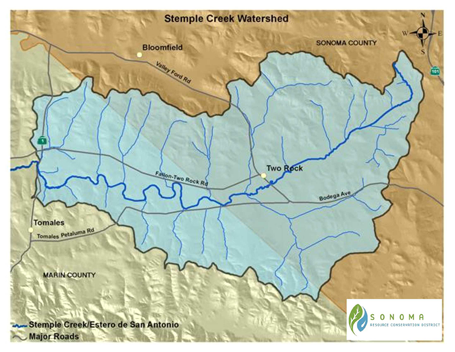
Watershed Overview
The Stemple Creek watershed is a sub-watershed of the Bodega Bay watershed, in Marin and Sonoma Counties. It lies approximately 40 miles northwest of San Francisco. Nearby cities include Petaluma, Cotati, and Rohnert Park, all within 5 miles of the eastern end of the watershed, and Santa Rosa, about 10 miles north. The watershed’s area is about 32,980 acres, or 51.5 square miles. Its east-west length is about 14 miles and its north-south dimension ranges from 3 to 6 miles. State Highway 1 crosses the watershed about 4 miles east of its outlet.
Stemple Creek flows westward through the watershed to its estuary, the Estero de San Antonio. The Estero empties into Bodega Bay, a broad indentation in the Pacific Coast. The Estero is an important coastal resource and is included in the Gulf of the Farallones National Marine Sanctuary.
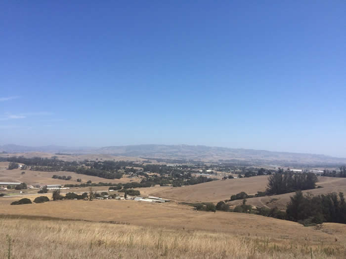
The watershed is characterized by rolling coastal hills, most with slopes of 30 percent or less. Slopes are generally steeper in the western part of the watershed. The hills flanking the creek’s valley on the north and south are higher than those across its eastern end. Elevations range from sea level at the mouth of the Estero, to about 300 feet at the eastern end of the watershed, 700 feet along the northern boundary, and 850 feet along the southern boundary.
Land Use
From the beginning of European settlement to the mid 1900s, the watershed has been farmed with small livestock herds and large areas of land cultivated for barley, wheat, vegetables, and potatoes. Poultry and egg production was an important part of the local economy from the 1930s through World War II.
Land use in the watershed is almost exclusively agricultural; 90% of the watershed is used for livestock grazing, as well as some dairies.
Water Quality Impairments
In 1990, Stemple Creek was listed on the federal Environmental Protection Agency’s 303(d) list as an impaired waterbody due to excessive nutrients and sediment.
In 1997, the North Coast Regional Water Quality Control Board adopted a Total Maximum Daily Load (TMDL) and Attainment Strategy for nutrients and sediment in the. The TMDL has been adopted into the Basin Plan for the North Coast.
The RCD’s 1994 Enhancement Plan for the watershed indicates that over 80% of the accelerated erosion in the watershed comes from the lower watershed with large gully systems as the primary source. Gully stabilization projects have been implemented by local landowners with support from the RCDs and the Natural Resource Conservation Service.
Vegetation
The land draining into Stemple Creek is largely grassland. Willows have been re-established along parts of the mainstem and tributary streams; coastal oak woodland can still be found along some of the higher tributaries. Eucalyptus, planted in rows for windbreaks and fuel, is now one of the most common trees.
Fish and Wildlife
Special-status species in the watershed include California freshwater shrimp, northwestern pond turtle, tidewater goby, Myrtle’s silverspot butterfly, and California red-legged frog.
Stemple Creek was once a marginal Coho salmon and steelhead trout stream. Farm ponds, especially those with shallow edges, now provide some of the best remaining habitat for waterfowl, northwestern pond turtles, and other aquatic species.
Current and Past RCD Programs
Planning
The RCD has worked with local agricultural landowners, often in partnership with the Marin RCD and NRCS, to improve water quality and maintain working landscapes in the watershed and is focuses on pursuing funding for water quality improvement on dairies in the watershed.
The RCD was awarded funding in 2012 through a partnership with multiple north coast RCD’s, the UC Cooperative Extension, and the Western United Dairymen to assist North Coast dairies with compliance with the upcoming North Coast Dairy Waiver.
Watershed Scale Planning
In 1994, the Sonoma RCD and the Marin RCD completed an Enhancement Plan for the Stemple Creek/Estero de San Antonio watershed. The goals of this plan include:
- Encourage the local community to take the lead in developing and implementing enhancement projects;
- Assist agricultural producers with practices that promote the conservation and enhancement of natural resources;
- Reduce pollutants entering Stemple Creek and the Estero;
- Reduce soil erosion;
- Encourage environmentally-sound management of rangeland;
- Conserve and enhance existing natural habitats;
- Restore the riparian corridor;
- Develop a long-term monitoring program; and
- Support agriculture as a major land use in the watershed.
Links to Important Programs in the Watershed
Marin Resource Conservation District (RCD)
Marin Carbon Project
Carbon Cycle Institute
Marin County Watershed Program
Students and Teachers Restoring a Watershed (STRAW)
Sonoma County Agricultural Preservation and Open Space District
Western United Dairymen
University of California Cooperative Extension, Sonoma County
For more information about the Stemple Creek Watershed, please contact Kari Wester at 707.569.1448 ext 101 or kwester@sonomarcd.org.