Petaluma River
District Watershed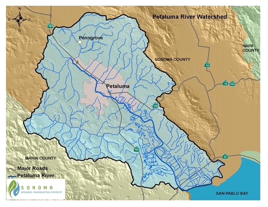


Watershed Overview
Located in southern Sonoma County, and a portion of northeastern Marin County, the Petaluma River Watershed encompasses a 146 square mile, pear-shaped basin. The watershed is approximately 19 miles long and 13 miles wide with the City of Petaluma near its center.
The headwaters and ephemeral tributaries of Petaluma River begin on the steep southwest slopes of Sonoma Mountain, the southern slopes of Mecham Hill, and the eastern slopes of Weigand’s Hill and Mt. Burdell. The confluence of Willow Brook, Liberty Creek, and Weigand’s Creek form the headwaters of the Petaluma Watershed just upstream of Rainsville Road and Stony Point Road. The Petaluma River itself flows across the Denman Flat area and through the City of Petaluma. Tidal influence extends upstream of the confluence with Lynch Creek (beyond the railroad crossing). A number of tributaries flow into the Petaluma River, the largest of which include: Lichau, Lynch, Washington Adobe and San Antonio Creeks. .
Land Use
Petaluma Watershed is diverse and includes the City of Petaluma as well as vital rural and agricultural lands. Mountainous or hilly upland areas comprise 56% of the watershed. Thirty-three percent of the watershed is valley, and the lower 11% are salt marshes. Sonoma Mountain at 2,295 feet is the highest point in the watershed. The Petaluma River empties into the northwest portion of San Pablo Bay.
The lower 12 miles of the Petaluma River flow through the Petaluma Marsh, the largest remaining salt marsh in San Pablo Bay. The marsh covers 5,000 acres and is surrounded by approximately 7,000 acres of reclaimed wetlands. Prior to reclamation, marshland elevations ranged from mean sea level to 3 feet above mean sea level.
Vegetation
The landscape within the Petaluma Watershed encompasses an area of great plant diversity and maintains a series of valuable biological characteristics. The complex network of tributaries feeding the Petaluma River and the slough itself play a significant role in maintaining the ecological systems of the region. Terrestrial vegetation types and riparian communities constitute an area of tremendous biodiversity, which provides habitat for a number of species. These vegetation types include varieties found in urban and agricultural areas, grasslands and oak savannahs, wetlands, vernal pools, riparian corridors, and both salt and brackish water marshlands.
Fish and Wildlife
The Petaluma River watershed includes a diversity of fresh water, brackish water, and salt water habitats. A significant amount of the state’s Pacific flyway migratory water birds rely on the watershed’s wetlands. Among the many diverse species found in the watershed is the great blue heron (Ardea herodias), great egret (Ardea alba), willow flycatcher, (Empidonax traillii), California red-legged frog (Rana aurora draytonii), bank swallow (Riparia riparia), steelhead (Oncorhynchus mykiss) and spring/winter-run Chinook salmon (Oncorhynchus tshawytscha), and the American badger (Taxidea taxus).
Petaluma Watershed Collaborative
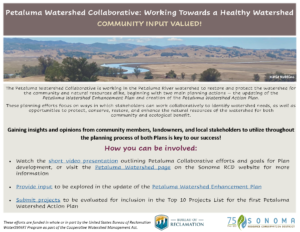
Funded by the Bureau of Reclamation’s WaterSMART program, Sonoma RCD is leading efforts to build the institutional capacity amongst local stakeholder groups to carry our sustainable watershed management and restoration in the Petaluma watershed by creating and sustaining a Petaluma River Watershed Collaborative. While funded under the current grant, Sonoma RCD will organize and hold stakeholder meetings in order to develop a revised version of the Draft Petaluma Watershed Enhancement Plan and an Action Plan to identify and advance watershed restoration projects and priorities.
Watch our quick video highlighting Collaborative efforts, here or click the YouTube image to the left.
Local landowners, residents, business owners, or individuals with interest are welcome to attend stakeholder meetings, as well as any additional watershed stakeholder that may have not been included within previous invitations. Meetings are held every other month virtually due to COVID-19.
Several interested party meetings geared to provide an overview of efforts, current information, and receive comments from interested parties will be held as well. Meeting agendas and notes will be posted below to notify of meeting date, time, and location.
Mission, Vision, and Goals of the Petaluma Watershed Collaborative
Governance of the Petaluma Watershed Collaborative
Petaluma Watershed Collaborative – 2021 Activities and Efforts
2021 Stakeholder Meetings
July 1, 2021
Agenda | Download PDF
Meeting Notes | Download PDF
April 9, 2021
Agenda | Download PDF
Meeting Notes | Download PDF
Meeting Slides | Download PDF
2020 Stakeholder Meetings
December 18, 2020
Agenda | Download PDF
Meeting Notes | Download PDF
September 17, 2020
Agenda | Download PDF
Meeting Notes | Download PDF
Meeting Slides | Download PDF
June 30, 2020
Agenda | Download PDF
Meeting Notes | Download PDF
Meeting Slides | Download PDF
May 1, 2020
Agenda | Download PDF
Meeting Notes | Download PDF
Meeting Slides | Download PDF
February 7, 2020
Agenda | Download PDF
Meeting Notes | Download PDF
2019 Meetings
October 2, 2019 Stakeholder Meeting
Agenda | Download PDF
Meeting Notes | Download PDF
December 6, 2019 Stakeholder Meeting
Agenda | Download PDF
Meeting Notes | Download PDF
Fore more information, please contacts us at info@sonomarcd.org.
Petaluma River Watershed Enhancement Plan
Last updated as a draft in 2015, the Petaluma River Watershed Enhancement Plan is due for an update and to be finalized! Stakeholders are reviewing and updating with the most recent information available in addition to identifying data gaps within the watershed that are critical for future success of watershed planning, restoration, and community activities. A new version of the Plan will be posted in 2024, please check back!
For more information, please contact us at info@sonomarcd.org.
Petaluma River Watershed Action Plan and Top 10 Projects
Intended as the “next step” for identifying and progressing project ideas in the Petaluma Watershed, the Action Plan will include a list of the Top 10 Projects recommended for local stakeholders and entities to pursue implementing as a next phase of Collaborative work.
Watershed stakeholders have collectively determined a development procedure and set of project selection criteria to score project ideas to be evaluated and potentially included as a Top 10 Project identified in the Action Plan. All are strongly encouraged to submit project ideas that have a watershed-related benefit!
For more information, please contact us info@sonomarcd.org.
Current and Past RCD Programs
Planning
- The RCD has worked with many agricultural producers in Petaluma River Watershed to enhance their farming operations and protect soil and water resources.
- The RCD is working with the Casa Grande Anglers, NOAA, and State Parks to develop a in-stream and/or riparian enhancement project on Adobe Creek, a tributary to the Petaluma River. The goals of the project is to enhance steelhead habitat and riparian habitat function and diversity.
Watershed Scale Planning
- Historical Hydrology Study of the Petaluma River Watershed: In partnership with the San Francisco Estuary Institute – Aquatic Science Center (SFEI), the RCD is collecting historical data about the streams encompassed by the Petaluma River Watershed in order to develop a comprehensive historical hydrology study. This study will help summarize the historical land use and hydrologic changes that have occurred within this watershed. This data will help inform and guide stakeholders and partner agencies when identifying future restoration and environmental enhancement projects for the Petaluma River and its tributaries.
- In 2013, the RCD worked to update the original Petaluma Watershed Enhancement Plan with watershed partners. In 2021, the RCD and stakeholders with the support of Reza Environmental are updating the existing document. Final draft coming in 2022.
On-the-Ground Projects
- Habitat Enhancement: The RCD plays an integral role implementing flood control, channel maintenance, and revegetation projects. Many of these projects have been implemented on Adobe, Lichau, Capri and Lynch, creeks and the Denman and Corona reaches along the Petaluma River.
- Levee Maintenance Program: In order to maintain the levees, landowners are required to obtain permits from many jurisdictional agencies. Currently, the RCD administers several permits issued by each regulatory agency for levee maintenance activities being completed by numerous landowners in the Petaluma River Watershed. Read more about the Levee here.
Agricultural and Environmental Education
- Annually the RCD hosts the Petaluma Fall Trash Cleanup Event with the Friends of the Petaluma River, where over 260 residents, youth and community members come out to help clean up the watershed along targeted tributaries and main stem access points.
- FARMS Leadership Program field days are annually hosted on private agricultural properties in South County.
- Agricultural Heritage Series public outings are annually held in partnership with the Sonoma Agricultural Preservation and Open Space District, touring conservation easement protected working agricultural properties.
Water Resources Management
- “Slow it, Spread It, Sink It, Store It!” (View & Download PDF) practices are implemented with landowners throughout the watershed. These practices can help to protect and replenish groundwater resources, reduce erosion and pollution, prevent flooding and increase water conservation and stormwater management.
- The RCD is an active member agency of the Petaluma Valley Groundwater Sustainability Agency (GSA).
Links to Important Organizations in the Watershed
Friends of the Petaluma River Watershed
North Bay Agricultural Alliance
City of Petaluma
Western United Dairymen
San Francisco Estuary Institute
National Oceanic and Atmospheric Administration, National Marine Fisheries Service
Natural Resources Conservation Service
Partners for Fish and Wildlife Program
United States Army Corps of Engineers
United States Department of Agriculture
United States Environmental Protection Agency
United States Fish & Wildlife Service
California Coastal Conservancy
California Department of Fish and Wildlife
California Regional Water Quality Control Boards, North Coast Region
California State Water Resources Control Board
University of California Cooperative Extension
Sonoma County Agricultural Preservation and Open Space District
Sonoma County Department of Transportation and Public Works
Sonoma County Permit and Resource Management Department
Sonoma County Public Health Division
Sonoma County Regional Parks Department
Sonoma County Water Agency
Sonoma County Agricultural Commissioner
San Francisco Bay Regional Water Quality Control Board
Sonoma County Farm Bureau
Sonoma County Farm Trails
Sonoma County Winegrape Commission
Sonoma Land Trust
California Waterfowl Association
Community Alliance of Family Farmers
Ducks Unlimited
Trout Unlimited
For more information about the Petaluma Watershed please contact Aaron Fairbrook at 707.569.1448 ext 106 or afairbrook@sonomarcd.org.