Guerneville North
District Watershed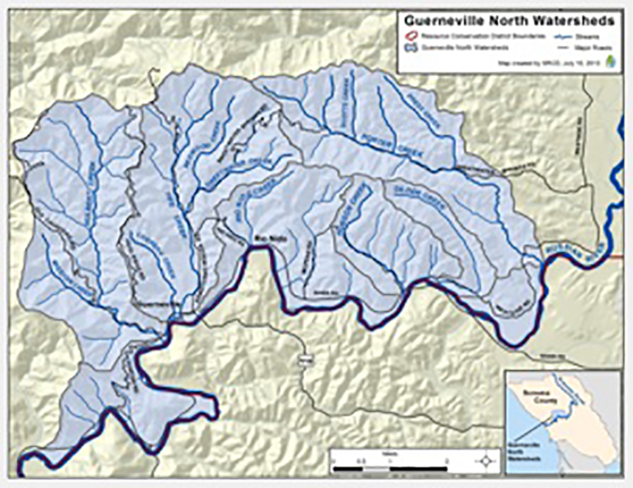
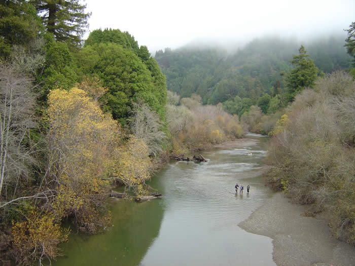
Watershed Overview
Hulbert Creek:
The Guerneville North Watershed area encompasses six separate subbasins that all drain directly into the lower Russian River between Town of Guerneville and Riverfront Regional Park. These subbasins include (from East to West) Porter Creek, Gilder Creek, Hobson Creek, Rio Nido Creek, Fife Creek, and Hulbert Creek.
Fife Creek:
Fife Creek and its tributaries drain a basin of approximately 6.7 square miles. Fife Creek is a second order stream and has approximately 4.8 miles of blue line stream, according to the USGS Guerneville, Cazadero, and Duncans Mills 7.5 minute quadrangles. Major tributaries include Redwood Creek, which was not surveyed due to lack of landowner access. Summer flow was measured as approximately 0.09 cfs on July 16 at Unit 157. Elevations range from about 126 feet at the mouth of the creek to 1400 feet in the headwaters. Redwood forest dominates the watershed, but there are zones of grassland and oak-woodland in the upper watershed. Land uses include timber harvesting, hard rock mining, State park areas (Armstrong Woods State Park and Austin Creek State Recreation Area), and urbanization. An abandoned hard rock mine is located on a tributary (Wilson/Redwood Creek). Stream mercury levels in 1980 were above EPA range but not deemed significant to wildlife. (From 1997 DFG Report)
Porter Creek:
Porter Creek and its tributaries drain a basin of approximately 7.3 square miles. Porter Creek is a second order stream and has approximately 7 miles of blue line stream, according to the USGS Guerneville 7.5 minute quadrangle. Major tributaries include Press Creek and Osborne Creek which are included in this report. Gordon Creek and Scotts Creek are also tributaries of Porter Creek, but were not surveyed due to lack of landowner access. Summer flow was measured as approximately 0.4 cfs on November 5, 1997. Elevations range from about 40 feet at the mouth of the creek to 1600 feet in the headwaters. Deciduous forest dominates the riparian corridor, but there are zones of conifers and evergreens along the lower floodplain, as well as grassland and oak-woodland in the upslope areas. The watershed is entirely privately owned, and managed for timber, vineyard and livestock production. (From 1997 DFG Report)
Hobson Creek:
Hobson Creek and its tributaries drain a basin of approximately 2.25 square miles. Hobson Creek is a second order stream and has approximately 2.91 miles of blue line stream, according to the USGS Guerneville 7.5 minute quadrangles. Elevations range from about 36 feet at the mouth of the creek to 1444 feet in the headwaters. Hardwood forest with a mix of conifers dominates the watershed, although hardwood forest is more prevalent in the lower watershed and mixed conifer/hardwood forest dominates the upper watershed. There are also herbaceous zones and shrub zones throughout the watershed. The watershed is entirely privately owned. (From 1997 DFG Report)
Land Use (Historic and Current)
Many of the subbasins are managed for timber, vineyard and livestock production. Land uses also include hard rock mining, State park areas (Armstrong Woods State Park and Austin Creek State Recreation Area), and urbanization in the Guerneville and Rio Nido Areas (Fife Creek and Rio Nido Creek)
Vegetation
These watersheds are characterized by Coastal Redwood and Douglas fir forests. The Armstrong Redwoods State Natural Preserve is located in the upper portion of the Fife Creek and Hulbert Creek watersheds, and hosts some of the oldest redwood trees in California. Grasslands with scattered oaks are also present throughout the different subbasins.
Fish and Wildlife
Wild juvenile coho salmon (Oncorhynchus kisutch), a federally endangered species, were observed in 2011 in Porter Creek. Coho stocking also took place in Porter Creek in 2011 by the Coho Captive Broodstock Program. Other listed species in the watersheds include the threatened steelhead trout, the California Red Legged Frog, and the Northern Spotted Owl.
Watershed Impairments
The houses built right along Fife and Hulbert Creeks in combination with other leaking septic systems have contributed to poor water quality in these streams leading to high coloform bacteria, sediment loading, and high summer temperatures.
Current and Past RCD Programs
In partnership with riparian landowners in the Guerneville North watershed, the RCD has undertaken a number of projects to enhance riparian and instream habitat and stabilize eroding streambanks along the Russian River and its tributaries. Examples include removal of a fish passage barrier on lower Porter Creek that took place in 2011, and a planned project to install a combination of 20 large wood and boulder structures in Porter Creek in order to enhance pools and create better habitat for fish and other aquatic organisms.
Links and Documents
UCCE Russian River Coho Salmon Captive Broodstock Program
Armstrong Redwoods Reserve
Stewards of the Coast and Redwoods
Useful Documents
- DFG Stream Surveys (Porter, Hobson, Fife, Hulbert, and Mission Creek)
- Russian River Creek Stewardship Monitoring and Assessment Report 1998 – 2004: View & Download PDF
- Coastal Tributary Improvement Program: Monitoring Summary Report 2006
- Russian River Creek Stewardship Program: Monitoring Summary Report 2005-2006
- Analysis of the Fife Creek Study Reach Survey Data 2005 – by Dennis Jackson (S:\Programs\Russian\Multiple Watershed Projects\SCWA Russian River Cooperative Agreement (SCWA)\RR Monitoring and Assessment Program-frannie to sort)
For more information about the Guerneville North Watershed please contact Aaron Fairbrook at 707.569.1448 ext 106 or afairbrook@sonomarcd.org.